
Reporting for this article was funded by Open Development Cambodia.
Nearly two decades after Cambodia began adopting carbon-credit programs for protected forests, satellite data suggest that tree cover continues to disappear inside many of the country’s flagship conservation landscapes.
Under the U.N.-backed REDD+ framework, countries receive money to protect forests for absorbing carbon dioxide and preventing emissions from deforestation.
However, satellite data between 2010 and 2025 suggest that tree cover continues to decline inside several REDD+ landscapes.
Across six REDD+ projects analyzed, five show tree-cover loss continuing at rates near or higher than before the conservation projects started. Open Development Cambodia compiled the data based on REDD+ boundaries and Global Nature Watch satellite data.
These projects can receive money for reducing carbon emissions even if there is deforestation. This is based on a system of “baseline scenarios,” where the REDD+ projects say there would be even fewer trees if not for their work. Several projects showed improvements in recent years.
A critic of the program, however, says Indigenous communities should instead lead forest conservation, based on practices that protected the areas for generations.
Tree-cover loss
The Tumring project in Kampong Thom showed the most tree-cover loss in the ODC data: After launching at the end of 2014, its tree-cover loss adds up to about half its total area, according to the satellite data. The rate of loss has decreased in the last five years.
Despite reports about deforestation, the project has denied large-scale logging and claimed hundreds of thousands of tons in net carbon-dioxide reductions. Mekong Independent has reached out to the project for comment.
The Oddar Meanchey REDD+ project has also consistently lost more forest cover each year since its launch in 2008 compared to the period before, the satellite data suggest. Its certification expired in 2018. The project has fared better in the past four years compared to the decade before.
A major customer, Virgin Atlantic, stopped buying carbon credits from it in 2018 as critics called the credits “bogus”: “They are based on emissions savings that never happened, because the forest was destroyed not protected.”
Mining in protected areas
The Lumphat Wildlife Sanctuary REDD+ launched in 2019. Since, it has lost tree cover at a low rate similar on average compared to the period before.
The Keo Seima REDD+ project, meanwhile, launched in 2010 and has mostly kept tree-cover loss below pre-project levels. Over 15 years it has lost less than 0.5% of the total project area in tree cover loss, according to the satellite data.
Nevertheless, surrounding protected forests have been under pressure. Since 2020, at least five mining companies have been granted hundreds of hectares in concessions in community-protected areas adjoining the Lumphat Wildlife Sanctuary. In 2023, the government approved a 4,000-hectare mining concession leading to warnings of “significant” destruction in the wider Keo Seima Wildlife Sanctuary’s “core” zone.
Hydropower
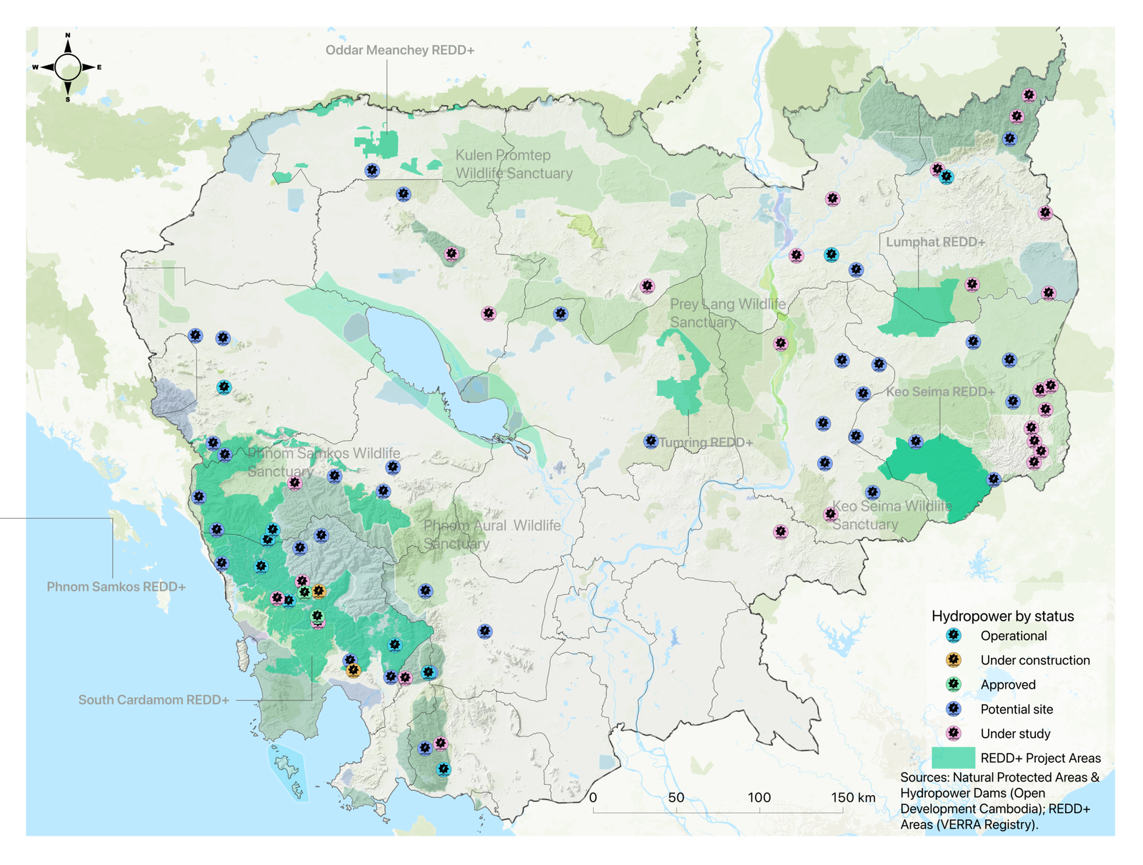
The Southern Cardamom REDD+ project was launched in 2016 with at least four Chinese-owned hydropower projects already built inside its boundaries. Then in 2024, the Cambodian government approved construction of a new 100-MW Stung Veal Thmor Kambot dam in the middle of the REDD+ project.
The neighboring Phnom Samkos REDD+ is in a similar situation: The year after its 2022 launch, the government approved the construction of the 150-MW Stung Meteuk series of dams. However, notorious tycoon Ly Yong Phat’s hydropower project was then temporarily suspended in 2024 over alleged environmental violations.
Recent satellite data suggest a small uptick in tree-cover loss in the Southern Cardamoms REDD+ project over the past three years, reaching its highest levels over the 25-year data period. It appears to have lost about 0.2% of the total project area in tree cover in 2024. Phnom Samkos has seen above-average but declining tree-cover loss for the same three years.
Satellite estimates
Wildlife Alliance, which manages the two projects working around the government-approved hydropower developments, said it monitored tree loss by combining satellite and drone imagery with on-the-ground patrols.
Global Nature Watch’s satellite data was useful to investigate forest cover at a national or jurisdictional level, but “must be used with extreme caution more locally (i.e. to analyse individual projects),” it said.
The data was not fine-tuned for different environments, and “we hope and expect this uncertainty will be reflected in any article you publish.”
Any forest loss and emissions impact from dam constructions will be assessed, and the number of carbon credits issued adjusted accordingly, it said.
Global Nature Watch also notes that it defines tree-cover loss as both temporary and permanent “removal of tree cover for any reason,” and is not necessarily human-caused or permanent deforestation.
A 2022 study by Everland, a company that provides strategic communications and marketing for REDD+ projects, says REDD+ projects that are losing forests are still faring better than nearby areas. The analysis, published in Nature subsidiary Scientific Reports, used Global Nature Watch data to estimate tree-cover loss in several protected areas.
The ‘baseline’
REDD+ projects calculate emissions reductions by comparing them to a business-as-usual scenario. This baseline estimates how much forest loss and greenhouse gas emissions would have occurred without the project.
This baseline is audited, but controversies remain. The Guardian reported in 2023 that globally, “more than 90% of rainforest carbon offsets by biggest certifier are worthless.” REDD+ claims did not represent “genuine carbon reductions,” and threats to forests were overstated, it said. The certifier, Verra, disputed the report as “absolutely incorrect.”
Frédéric Bourdier, a researcher with the University Paris-Sorbonne, said baseline calculations required reliably forecasting the future, and large assessment errors had been found.
The difficulty of measuring carbon stored in forests was compounded by “the dark and messy art” of peering into the future and the fact that projects produce their own baseline estimates, which are then assessed by Verra-approved third-parties.
“REDD+ programs provide, above all, a right to pollute,” he said. “These companies are buying rights that allow them to continue polluting with impunity, without changing their predatory practices. To continue business as usual.”
Verra has not responded to a request for comment.
Cambodia has 12 REDD+ projects, seven of which have been registered with Verra, according to a 2025 study. Not all projects have been fully verified or have issued carbon credits. Wildlife Alliance noted that its Phnom Samkos project had yet to undergo validation or verification. The Environment Ministry’s REDD+ Cambodia website has an incomplete listing of projects, while Verra’s database appears to list eight relevant projects.
The six projects analyzed by ODC were those with boundary information available from the Verra registry in KML format. ODC then used these publicly available project boundaries to estimate annual tree‑cover loss data from Global Nature Watch’s map catalog for the years 2010-2025.
Beyond REDD+
Cambodia’s REDD+ projects are not alone in facing reports of deforestation.
Ma Chettra, an environmental activist, regularly patrols the Prey Preah Roka and Prey Lang wildlife sanctuaries in Preah Vihear province. During his patrols, he said he frequently encounters illegal logging and forest encroachment.
He said he could not determine whether deforestation had increased or decreased overall, but forest crimes appeared to occur almost every day.
“There is not a patrol where we don’t see logging or hear the sound of chainsaws in the forest,” he said.
On July 28, Chettra and representatives of the Prey Lang Community Network were invited by the Ministry of Environment to provide evidence and respond to questions regarding a viral video he posted alleging illegal logging inside the Prey Lang Wildlife Sanctuary.
Khvay Atitya, spokesperson for the Ministry of Environment, denied the findings around forest loss in REDD+ projects, saying “I don’t have this information.”
Before a project can be implemented and carbon credits sold, it must meet a set of criteria to reduce greenhouse gas emissions, protect ecosystems and improve the livelihoods of local communities, he said.
“We have a Safeguard Information System (SIS), including the principle of obtaining Free, Prior, and Informed Consent from local communities and Indigenous peoples.”
Khvay Atitya added that projects must also include a grievance mechanism to address impacts or land disputes arising from the project and clearly define how revenue from carbon credit sales is distributed back to communities.
Wildlife Alliance said its projects had provided clean water, health care and education to local communities, including $3 million invested in the Southern Cardamoms area. Local people overwhelmingly support the project, it said. However, Human Rights Watch has questioned its consent process, accusing the project of violating Indigenous communities’ rights.
Indigenous alternative
Frédéric Bourdier, the University Paris-Sorbonne researcher, argued that carbon trading was not the answer. “Not at all. Neither here nor elsewhere.”
“One interesting alternative would be to listen and receive inspiration from Indigenous peoples” who had long managed their territories in relative harmony with nature, he said.
He pointed to effective examples in India, South America and Canada where governments had allowed local communities to manage their own territories with limited state intervention.
But such approaches were rarely embraced by policymakers or conservation organizations. “At least in Cambodia, probably because civil society movements are not easy to emerge,” he said.
As the climate crisis deepened, the only real worldwide alternative was to drastically change our collective ways of life, he said.
This article is published as Creative Commons.
The article was updated on September 2 with additional information about methodology.